Research
Research to Improve Indigenous Health
Indigenous peoples have long faced disproportionate risks from epidemic diseases and precarious health conditions. COVID-19 was no exception (Simionatto, Barbosa, and Marchioro 2020).
Projeto Dourados continues our collaboration that started when Albuquerque, Rezende, and Simionatto—together with other co-authors—tracked the spread of different SARS-CoV-2 variants within the Dourados Indigenous Reserve (Oliveira et al. 2023).
Our current research builds on their work by using original data to explain how social structure shaped transmission in the Reserve during COVID-19. Social structure means who interacts with whom, and how often. Geography shapes social structure: we interact more often with those nearby than far away. Cultural, ethnic, and economic groupings also shape these patterns.
The goal of this research is to support residents of the Dourados Indigenous Reserve in preparing for future pandemics. We develop computational tools that allow different response strategies to be explored through simulation, making it possible to anticipate trade-offs before crises arise.
While grounded in the context of Dourados, we intend our work to be adaptable to improve preparedness and disease prevention in other Indigenous communities in Brazil and beyond.
The Dourados Indigenous Reserve
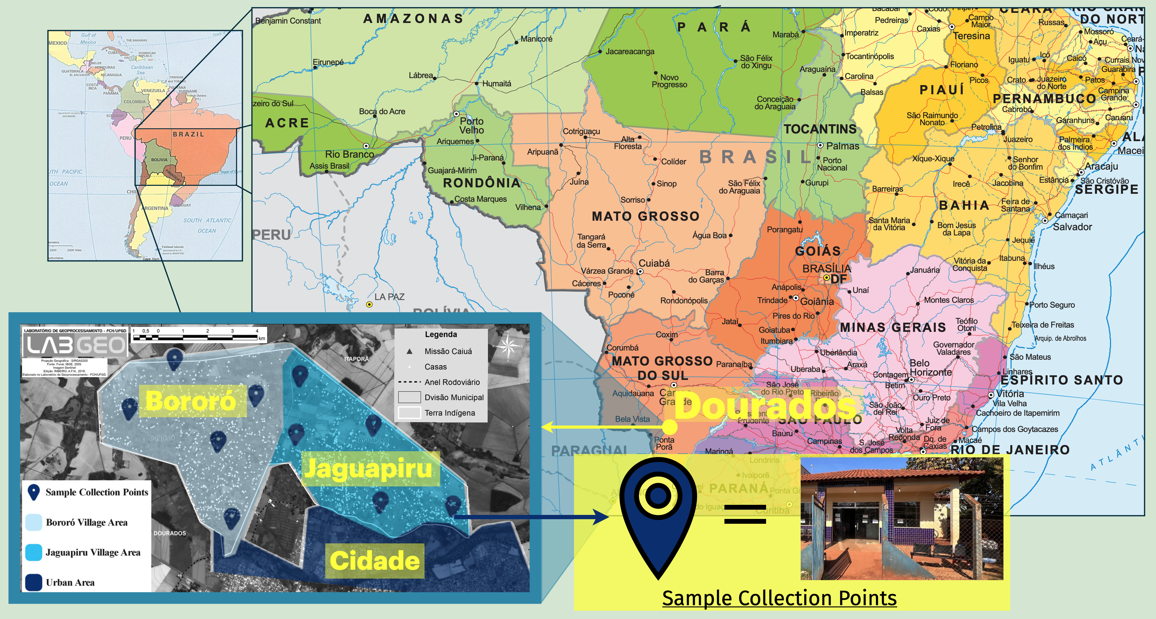
The Dourados Indigenous Reserve is located in the state of Mato Grosso do Sul, in southwestern Brazil, adjacent to the city of Dourados (Figure 1). The Reserve lies within a region shaped by long histories of Indigenous settlement, displacement, and state-led reservation policies, which brought together multiple Indigenous groups into a shared territory.
Today, the Reserve is home to approximately 18,000 residents living in two villages: Bororó and Jaguapiru. Jaguapiru is the larger of the two, with roughly twice the population of Bororó. The population includes members of multiple Indigenous groups, with Guarani Kaiowa and Terena comprising the largest shares of residents.
The spatial organization of the Reserve reflects its proximity to the city of Dourados while remaining socially and administratively distinct. Figure 1 situates the Reserve within Brazil and shows the relative locations of Bororó and Jaguapiru, along with sites used for public health surveillance during the COVID-19 pandemic.
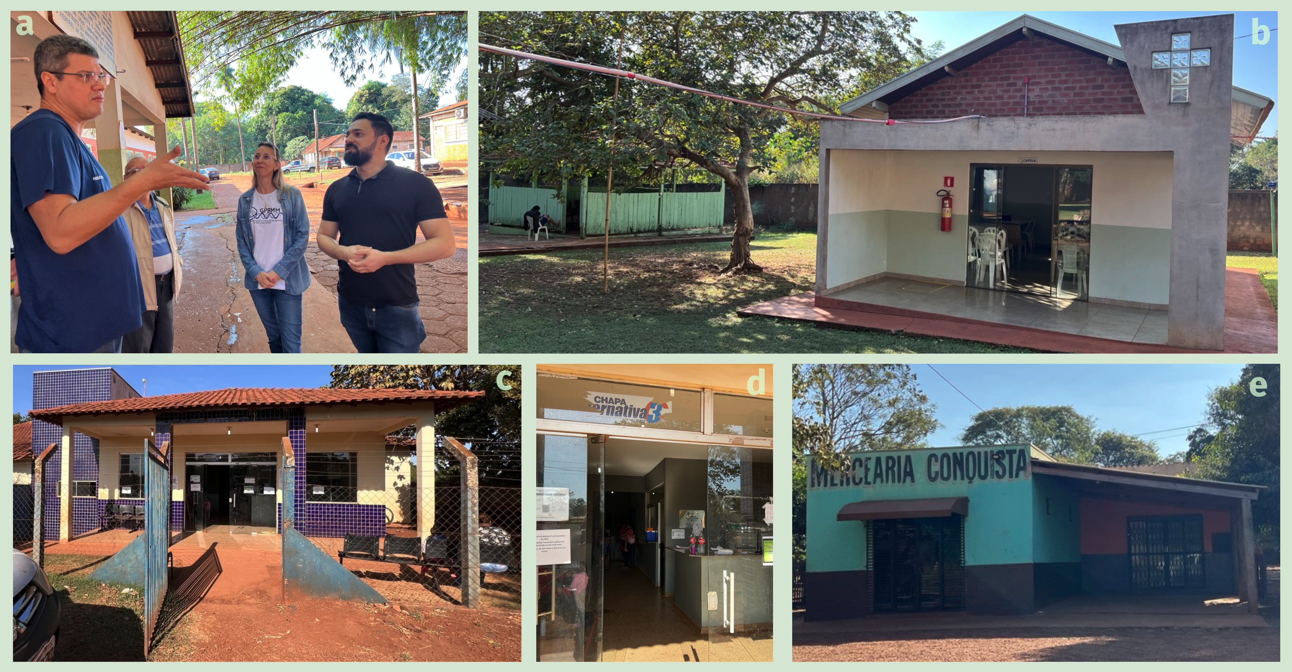
Daily life in the Reserve is supported by a mix of shared institutions and local infrastructure (Figure 2). The Reserve’s hospital serves as a central hub for care and includes both a Christian chapel and an outdoor ceremonial structure with a fire pit used for Indigenous spiritual practices. Smaller public health stations and independent storefronts provide essential services throughout the Reserve.
How Social Structure Shaped COVID-19 in the Reserve
Albuquerque, Rezenende, Simionatto, and their co-authors created a system for genomic sequencing and monitoring to track the spread of COVID-19 variants in the Reserve during the pandemic. Differences in arrival timing could determine which public health response would be most effective. This allowed the authors to confirm that SARS-CoV-2 variants arrived in the Reserve when they arrived elsewhere in Brazil. However several observed transmission patters seem to be uniquely shaped by the social, economic, and geographic structure of the Reserve.
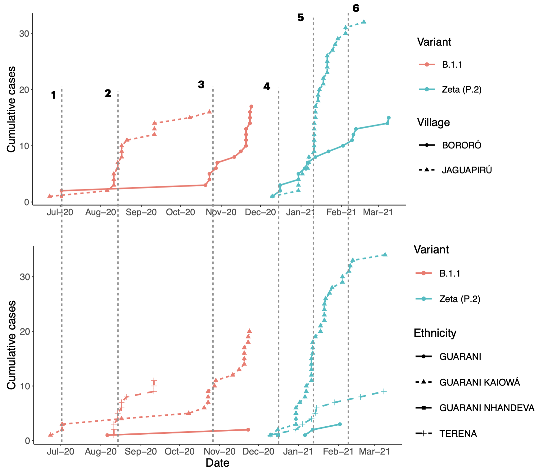
In July, 2020, the first COVID cases (variant B.1.1) were detected both in the towns of Jaguapiru and Bororó. Apparently, however, only Guarani Kaiowá ethnicity individuals were among the first infected (Time 1 in Figure 3). About a month later, a sharp increase in cases was detected—but in this case, infections were detected almost exclusively among ethnic Terena residents, and only in the Jaguapiru village (Time 2 in Figure 3). Variant B.1.1 continued to spread in the Jaguapiru village over September and August, 2020, but infected individuals were of a mix of Terena and Guarani ethnicities over these months.
The final surge in variant B.1.1 cases occurred several months later and was concentrated primarily in the Bororó village (Time 3 in Figure 3). Unlike earlier phases of spread, this increase was driven largely by infections among Guarani individuals. By this point, the variant had already circulated within Jaguapiru across multiple ethnic groups, suggesting that the later rise in Bororó reflected delayed transmission along interaction pathways linking the two villages rather than a new introduction.
A similar pattern was observed following the introduction of the Zeta (P.2) variant at the end of 2020. Zeta cases rose rapidly in Jaguapiru around the holiday season, particularly among Guarani individuals (Times 4–5 in Figure 3), before appearing later in Bororó, where infections were again concentrated among Terena residents (Time 6). Because many individuals had already been infected during earlier waves, this surge is consistent with a combination of new infections and reinfections, rather than simple spread through a fully susceptible population.
Across both variants, transmission followed a repeated sequence: early increases within specific ethnic groups and villages, followed by delayed spread to other groups and locations. The recurrence of this pattern under different variants, and under conditions where prior infection was common, suggests that socially structured interaction pathways continued to shape transmission even in the presence of partial immunity.
Taken together, these patterns indicate that COVID-19 transmission within the Reserve was shaped not only by when variants arrived, but by how social interactions were structured across ethnic and village boundaries. Rather than diffusing uniformly through the population, infections appear to have moved along socially patterned pathways, reflecting differences in contact frequency and mixing across groups. These dynamics motivate a closer examination of social structure as a key driver of disease spread within the Reserve.
Unanswered Questions
The patterns described above suggest that social structure played a central role in shaping COVID-19 transmission within the Reserve. However, several key questions remain unresolved.
Perhaps Jaguapiru’s proximity to the city drove higher infection rates there. If this were true, future pandemic preparedness plans might do well to focus resources on Jaguapiru residents who travel to the city due to economic necessity.
More generally, no matter how SARS-CoV-2 entered the Reserve, the structure of social interaction determines how it—and any other pathogen—spreads. What remains unclear is which way of defining social groups best represents the observed COVID-19 dynamics.
Current Research Project
Turner is leading an effort to formalize the hypotheses above into an epidemiological simulation and statistical model of COVID-19 transmission in the Reserve. The goal is to support public health planning for interventions such as incentivizing staying home, so that residents do not feel economically compelled to travel during outbreaks.
We begin by using data gathered by Albuquerque, Rezende, and Simionatto to fit the simulation model using statistical inference. In practice, this means identifying which model configurations generate simulated data that most closely match observed epidemiological patterns.
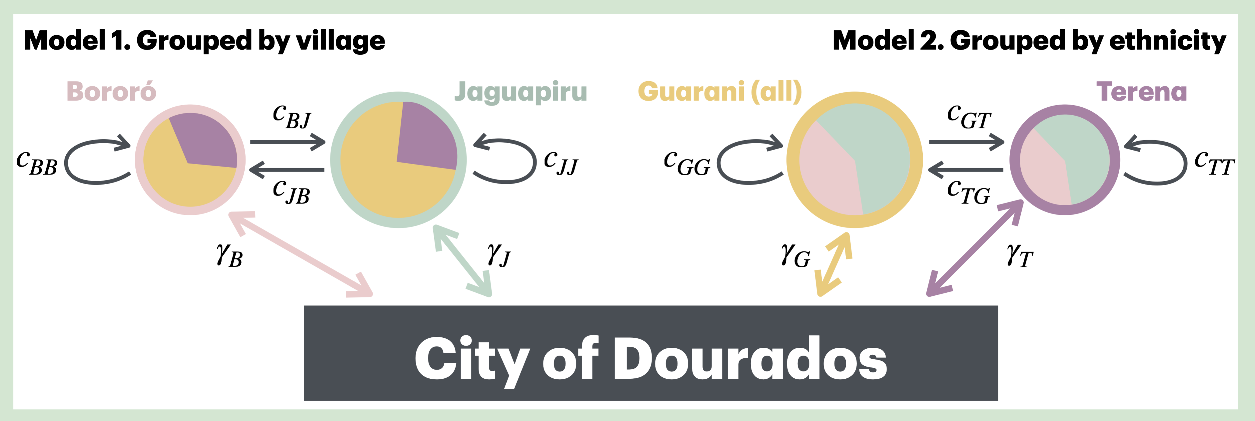
The model represents disease transmission through travel between the Reserve and the city of Dourados, followed by local spread shaped by interpersonal contact networks. A schematic overview of this structure is shown in Figure 4, where mobility and contact behaviors for different social groups are represented symbolically.
To determine which version of this model most faithfully represents COVID-19 in the Reserve, we infer the following:
- Which social groupings (village, ethnicity, or village × ethnicity) produce models that best match the observed data?
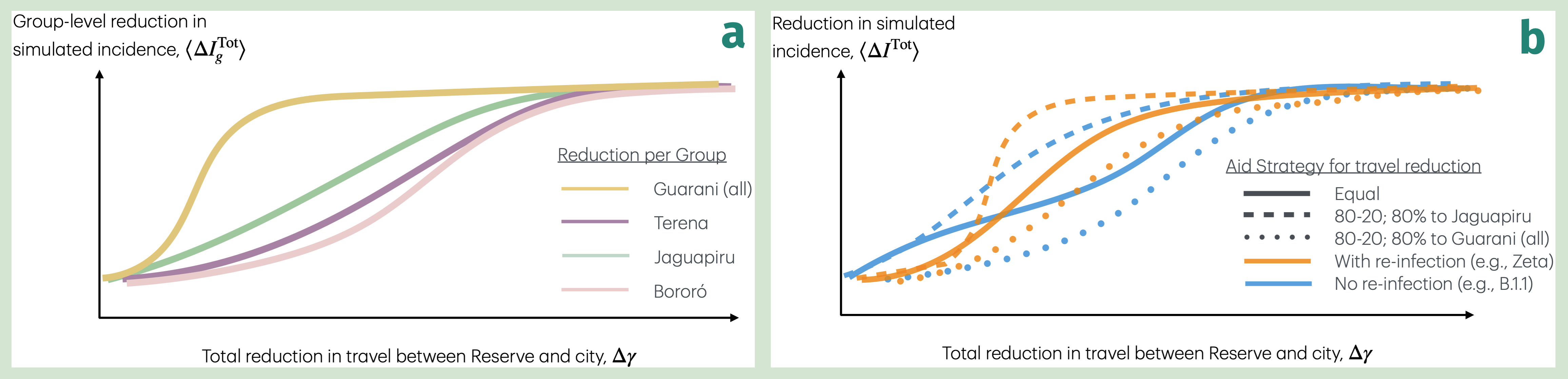
- Was travel to the city a significant factor in importing different variants?
- Did reinfection play a significant role in the Zeta outbreak in the Reserve?
While understanding these dynamics is valuable in its own right, our primary aim is to use this knowledge to prepare effective social interventions before outbreaks escalate. Once a faithful model has been inferred, it can be put to work evaluating intervention strategies.
We use the model to infer which intervention strategies most effectively limit the number of cases under constrained resources. Different strategies correspond to different expenditures aimed at producing specific social changes. In the model, these changes are represented as adjustments to parameters governing mobility and social contact structure.
For example, public funds might be used to reduce travel to the city for one, several, or all social groups. Resources need not be allocated evenly. Given Jaguapiru’s proximity to the city, one might plausibly expect residents of Jaguapiru to travel more frequently than those in Bororó.
Long-term Vision
Efficiency is essential: resources are limited, and we do not have the time or capacity to experiment freely in the real world.
Statistical and simulation studies are valuable not only because they help us understand and predict real-world phenomena, but also because they highlight gaps in our knowledge. These gaps can point to where additional basic research—such as anthropological or ethnographic work—would be most valuable.
We see a unique opportunity to advance public health for Indigenous communities. Our long-term vision includes building a vibrant team of faculty and student researchers working on the ground in Dourados, documenting the Reserve and the public health efforts taking place there. This on-the-ground engagement is essential for grounding the development of effective computational tools for public health policy.